Hope for April?
Uncertainty remains, but the end of April looks promising
So, it’s been a particularly shitty April. Historically, it’s a pretty decent month for us. Not as good as March (which also kinda sucked), but not as inconsistent as February (again, historically). It’s pretty crazy to be sitting here at almost the end of April and only having one real day of over 7 second swell.
Unfortunately, we’ve had a particularly terrible run of weak and small surf. At least the air temps have been warmer.
But, after what will be a slow weak in terms of surf, the last week of April may deliver one or two more rounds of at least fun waves. That said, I’m not expecting anything firing at this time. Let’s look at some charts.
The Setup
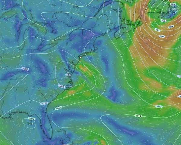
While there is still some uncertainty in the forecast, it’s looking like we should see something around next Sunday/Monday. The Euro has been extremely consistent with the path of a weak low pressure system that puts the center directly off Maryland/Delaware and in our swell window. The southern end of the mid-Atlantic looks to get the best of it (wind TBD).

source: windy.com
While the east swell direction isn’t what I’d like to see given the state of our sandbars, the shorter period swell should play a little better than the 10+ second swell we saw a couple of weeks ago.
While the Euro has been consistent, the GFS has been more variable. I’ve seen some runs showing similar track, but it’s mainly showing a due eastward track, putting the center too far south for us to see anything signifcant. We should still get a weak south swell if this turns out to be the case, but it would end up in the 6 second range again, unfortunately. Though the swell angle would be more favorable.
source: windy.com
I’m favoring the Euro right now, considering how consistent it’s been on it’s solution. While it’s too early for specifics, let’s look at the wave chart and see where most of the swell is going:
source: windy.com
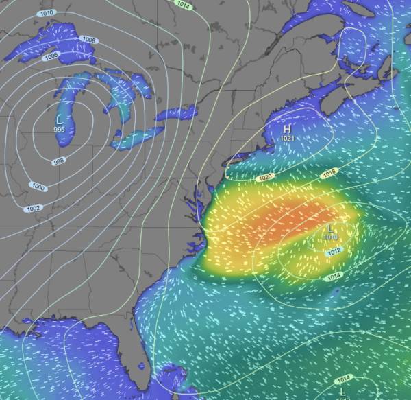
The presense of weak high pressure to the north of this area of low pressure helps create a pressure gradient and a easterly wind fetch. That said, the strongest gradient occurs as high pressure moves southeast over the Great Lakes. The positioning of that lends to stronger northeast winds, the result of which is more swell headed to North Carolina.
As high pressure moves in, we end up with more onshore winds and no clean up is guaranteed. A stronger region of low pressure is expected to follow shortly behind and wind is expected to be strong from the south by Tuesday AM for another prefrontal south swell (worth watching). We will see a westerly wind shift following the passage of that low pressure system (if it follows forecast).
General Thoughts
At least there appears to be something on the charts. The GFS is lagging on both of these potential swells. I put more stock in the Euro this far out. The American ensemble model (GEFS) is consistently showing low pressure over the Eastern U.S. for that time period, so it’s mainly a matter of the track the eventual low will take (and where it forms).
This has been a pretty rough start to Spring and we’d normally be seeing more quality surf. I’m struggling to remember a time with as little actual swell, even the normal 7-9 second stuff. That mixed with the sand issues from last year’s beach replenishment hasn’t made for the best year of surf.
I don’t like looking much more than a few days out, it’s too easy to get disappointed when things change. That said, the setup for late month and early May gives some reason for optimism.