Another Nor'easter?
The first swell of February is looking good!
The Setup
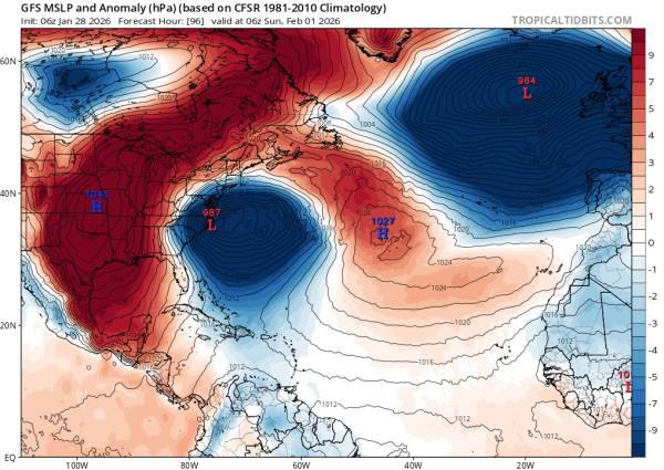
Courtesy of tropicaltidbits.com
We have another Miller B Nor’easter that’s expected to impact our region on Sunday 2/01 and likely drop a fair amount of snow in VA and NC. This is a pretty powerful storm and sea heights are likely to reach close to 20 feet, especially towards the Outer Banks of North Carolina. Hatteras Island is likely to get the best of this swell in terms of wave size, but southern NJ should have really good conditions as well.
The chart above isn’t all that dissimilar from what we saw last weekend/Monday. Again, we have a Nor’easter pushing into a region of high pressure to its north, creating a strong fetch of easterly winds (in this case more northeasterly if things stay the same). However, this system is stronger and the wave heights will be considerably greater.
The Waves
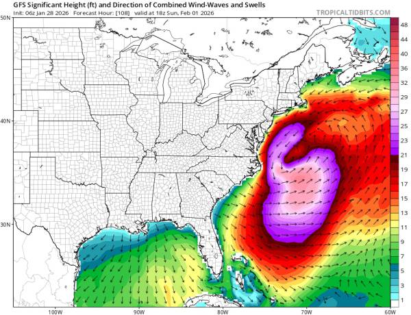
Courtesy of tropicaltidbits.com
This system is expected to generate the largest waves we’ve seen in some time. There’s still some uncertainty in the resultant swell direction between the major atmoshperic models and I’d expect some changes to the swell numbers in the coming days. With that said, we’re looking at 20+ foot seas aimed directly at Hatteras Island for next Sunday and seas in the 15 foot range for New Jersey.
It’s possible that southern NJ will have the best actual conditions for surfing during the peak of the swell. Hatteras is definitely in contention though.
It shouldn’t need to be said, but this is one for the experts if it comes together.
Updates as of 1/31
Well, swell numbers have trended down (not totally unexpected). This is still a very strong storm system and is pushing out 20+ft seas that are fairly poorly aimed at any actual land. At least for the mainland U.S., North Carolina will see the strongest waves from this system.
That said, we’re still looking at solid mid-period surf for early next week. Sunday 2/1, at this point, looks like a wash for Monmouth County. Ocean County cleans up earlier, but swell heights will be lower (but it’ll handle the direction better). If you’re not looking to drive, Monday mid-morning and mid-afternoon will be the best conditions. The large tide swing limits windows of surfability, but there will be plenty of waves if you pick your windows carefully.
Given the easterly swell direction (almost straight in to our beaches) and the mid-period swell, closeouts will be an issue.
Wind is expected to be out of the northwest and not too strong all day.
All in all, Monday should be pretty user friendly (although solid). Largest conditions early (around head high) before fading to around chest high late day.
The Leftovers
Tuesday is looking pretty small at this point. Although swell tables are calling ~2.5ft@11, that will include some NW swell from the sustained offshore winds. Currently, I’m expecting closer to 1.5ft@11s on the buoys for Tuesday AM. At this point, I’m calling it a coin flip as for whether there will be enough for a longboard in the AM. The early AM low tide will need to be avoided again. Late AM is the best window if there is surf.
Pattern Shift?
Like always, it’s too early to say, but it’s interesting to see Nor’easters again. For awhile we’ve only really seen steep-south prefrontal swells that tend to be lower period and quite soft. I can say, as a daily watcher of the charts, that I’m starting to see the tracks of low pressure systems change over the next couple of weeks. I’m starting to see more southerly tracks than I’ve been seeing over the past three months or so. But, along with that, low pressure seems to be dominating over the west/central Atlantic, which means that there isn’t any high pressure to bump up against and create wind/swell.