Weekend Nor'easter
A solid swell is likely
What Model Runs have been Saying
It took awhile, but the GFS model has started to agree with the Euro over the past several runs. Typically, the Euro is more accurate further out, and has had a better grasp on our weather over the past month or so. Let’s look at a couple of charts:
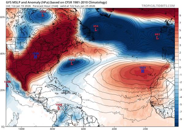
Courtesy of tropicaltidbits.com
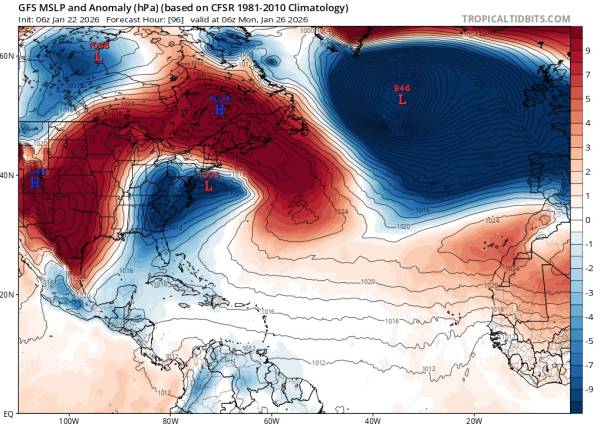
Courtesy of tropicaltidbits.com
The main difference between these two charts is the strength of the high pressure in the Central Atlantic. Early model runs were suggesting weaker high pressure over the Central Atlantic and stronger high pressure over the East Coast, leading to a more eastward storm track and an early exit. This would still generate some solid swell for the southeast, but we would’nt have seen much from that outcome.
Recent model runs (2nd image) show stronger high pressure over the Central Atlantic and a more northeast storm track. This track puts that area of low pressure squarely in our swell window. While it’s still pretty far out, it’s safe to say that we will see some solid surf from this system.
The Conditions
Based on current model runs, we should see well overhead waves on 1/26, with the swell peaking around 8am. Breaking wave heights could be in the 10ft range early. Definitely a day for the experts if it comes together. Early forecasts are showing NW wind for the afternoon. This would lead to decently clean conditions. Finding a bar will be a challenge.
As of 1/25, I’m not expecting much in the way of leftovers for Tuesday, 1/27. Some longboard waves perhaps.
Update as of 1/25
Unfortunately, this has trended down over the past three days or so. But there are some upsides. We’re seeing a swell mix of SE and E swells which should lend itself to breaking a little better here in Monmouth County than the original swell angles of ~114 degrees or so. While there won’t be well overhead surf, waves should still be in the head high+ range early before fading to around shoulder high by end of daylight hours.
The wind forecast looks pretty good, with offshores expected around 1am. This keeps trending earlier and earlier (one of the reasons we see less swell).
Originally, I was hoping we would see leftovers on Tuesday and even Wednesday. Given the track/speed of this low pressure system, we definitely won’t be seeing leftovers on Wednesday and as of 1/25, I’m not expecting much on Tuesday either. Overall, I’d try to get out there on Monday if you want to get some decent waves.