Model Divergence for the Back Half of December
A look at diverging models
Looking at 12/14
Let’s start with the charts:
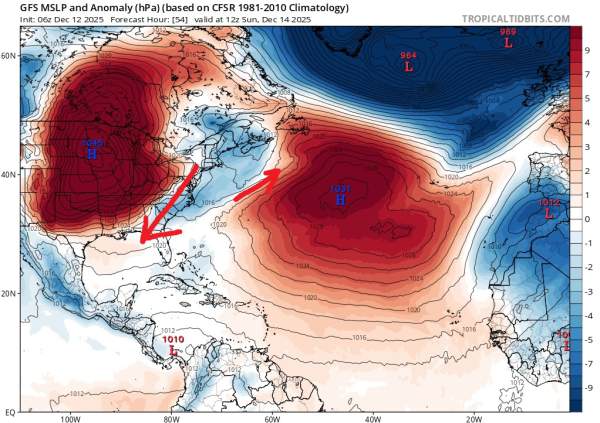
Courtesy of tropicaltidbits.com
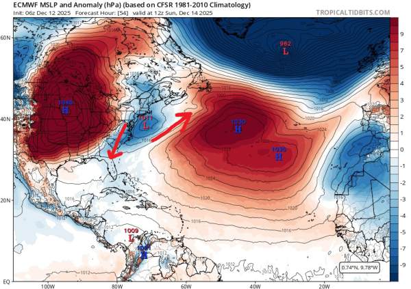
Courtesy of tropicaltidbits.com
I used the MSLP anomaly charts here rather than surface wind because it’s a little bit easier to see what’s going on (in my opinion). Starting with the first plot, this is the GFS surface anomaly chart, where you can see two large areas of high pressure (red) over the Mid-West and Central Atlantic. Between these areas of high pressure is a weak area of low pressure (blue). I added red arrows to show wind direction. The second chart is the ECMWF model and shows a similar setup, but one where the area of low pressure is much better developed (although still weak).
This area of low pressure is expected to move off the North Carolina coast and track northeast (and give us snow). Currently, no model is suggesting we see swellf from this system. If the wind field is as the models describe it currently, we won’t. I think there is a lower probability of decent surf from this system, but there is a chance that we see some waves. That said, it would be very short lived due to that giant area of high pressure moving in swiftly behind it.
Looking at 12/19
This is another situation where the GFS and ECMWF models are diverging. Originially, it looked like a good setup for our region on both models, but GFS runs in recent days are pretty terrible. The charts:
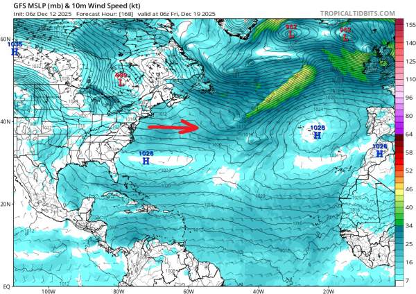
GFS Model. Courtesy of tropicaltidbits.com
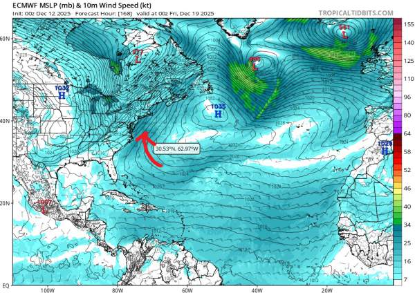
ECMWF Model. Courtesy of tropicaltidbits.com
For these, I went back to the wind charts as theyshow the situation clearly enough. Here we have two completely different versions of events for 12/19. The GFS model run shows a scenario with no swell and relatively minor impacts to our area from a somewhat weak area of low pressure over the Great Lakes (too far North) and a somewhat strong but too far south area of high pressure off South Carolina. Again, this is a bad scenario.
The Euro is showing a much more fruitful scenario, with a powerful low pressure system far north of the Great Lakes interacting with a large High Pressure system southeast of the Maritimes. We can see a fairly large fetch of S-SSW winds that would generate some decent, likely mid-period swell for our region.
Early runs of the GFS look more like current runs of the ECMWF. Hopefully that’s the case.
Christmas Swell?
The week of 12/20 - 12/28 looks fairly active with a couple of days worth checking. Charts are showing a well located area of high pressure in the Central Atlantic that could help generate some small but potentially fun swell around 12/20. We have another setup around 12/23 that could offer a quick windswell from an area of low pressure moving over the Great Lakes (low probability). Lastly, there have been some model runs that have shown a nice setup for 12/25 or 12/26. Ensemble runs have been less positive, but it’s still a long way out.