Swell Event for the First Week of August
More summer surf is on the way!
The Setup
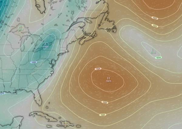
source: windy.com
Similar to the other few south swells we’ve seen lately, this one is a result of a low pressure system interacting with high pressure setup over the Central Atlantic. There are a few key differences from what we’ve seen lately though.
First, this low (blue region) is further south and actually was tracking directly over the Ohio Valley (moved north as it ran into the ridge over the Atlantic). The ideal situation is high pressure located north of a low tracking across the U.S., but in this case, they are at a relatively close latitude. So, while we won’t see a more powerful SE swell, this does mean that the predominant direction of the wind fetch will be almost true South. Most of the south swells we’ve seen have had a low pressure tracking further North (over the Great Lakes) with high pressure to it’s southeast. This creats a SSW wind fetch and swell that mainly heads away from our area, rather than towards it.
Secondly, we have a strong ridge over the West Atlantic. This blocks the eastward movement of our low pressure system and creates a sustained fetch of south wind. Let’s take a look at the wind chart:
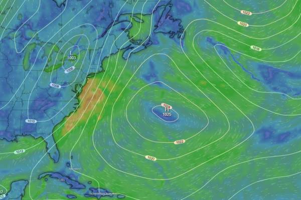
source: windy.com
As you can see, we have a decent sized fetch (for a south swell).
While we have a solid setup in terms of wave production, that ridge over the West Atlantic does have a few downsides. Most of the south swells we’ve seen lately have allowed the low to continue to move northeast past our region which leads to the wind switch that we all know and love. However, due to the blocking affect of that ridge, this low is mainly moving NNE and will continue to interact with high pressure, leading to sustained SSW winds until high pressure once again settles over our region overnight Monday.
As that high pressure moves in, the wind is expected to turn directly out of the North for Tuesday AM.
The Waves
While the wind forecast could certainly be better, I’m still expecting surfable conditions on both Monday and Tuesday, with the best conditions expected Monday evening at spots with south wind protection. For everywhere else, Tuesday AM is likely to be better, but there’s still some uncertainty in the wind forecast.
Let’s look at some plots:
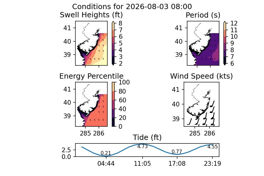
Wave heights are expected to peak in the AM and slowly fade through Tuesday night. Model forecasts are putting the AM on Monday at around head high with spots in North Ocean County and LBI likely pushing into the overhead range.
Wind is expected to be strong SSW early and most spots are looking pretty poor.
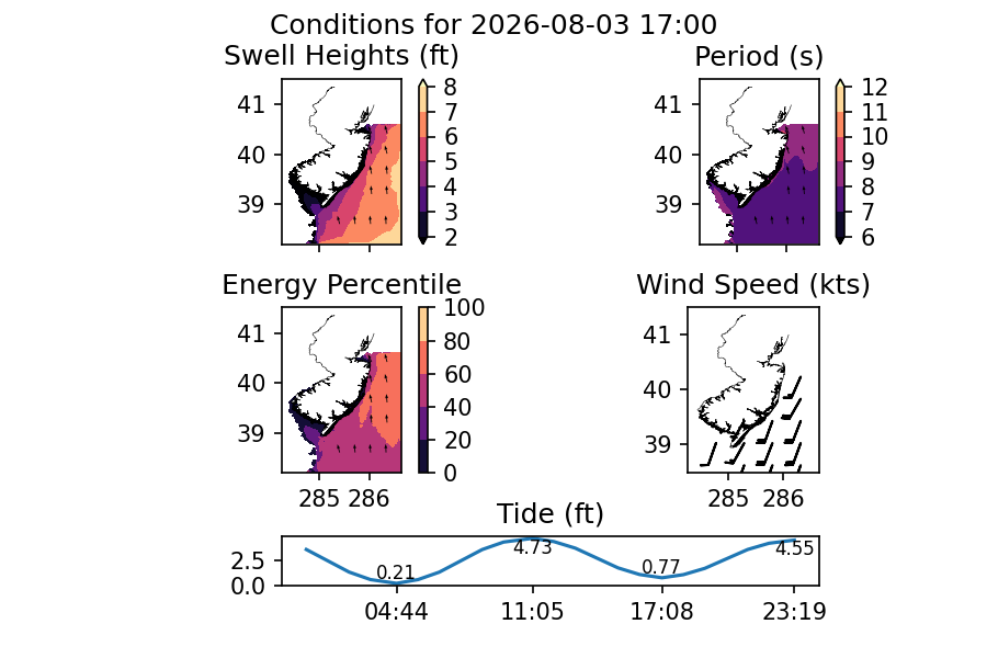
Wave heights are still expected to be in the chest-head high range as we approach the end of day with larger sets expected in Ocean County. Wind should start to back off a bit late day and favors spots further north (or those with south wind protection).
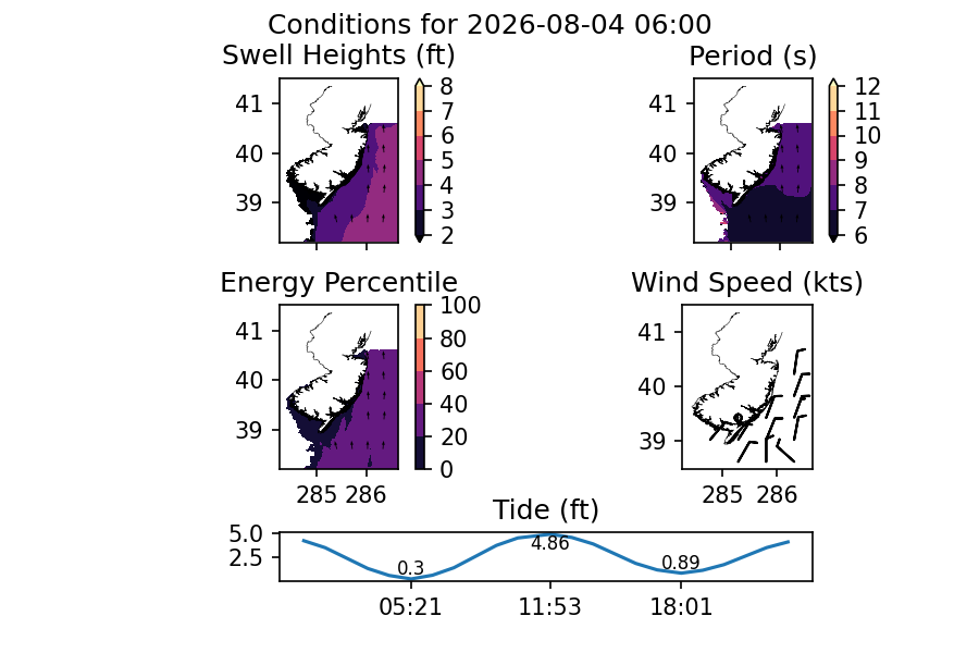
Moving into Tuesday, the best conditions are likely in the AM (tide depending). Given the swell angle, I’d expect low tide to be doable, especially given that we aren’t expecting a huge tide swing. That said, we could be looking at 5-10kts north wind, which isn’t ideal. Monmouth certainly handles that better than spots further south, but expect a bit of weirdness on it if that comes to pass.
Wind is expected to turn side-onshore for the afternoon. I’d get on it before that happens.
Conclusion
In general, this is looking like the strongest swell event of the past couple of months and is as solid as surf gets around here until tropical storms start picking up. While a wind switch isn’t looking like it’ll be in the cards, we’re still looking at doable solid surf.
I’d expect a strong south current which will help a bit with the crowds (except spots where it’d matter most, lol).
As always, south wind tends to cause upwelling. I’d have a wetsuit for early morning sessions. That said, warmer temps are expected this week, so don’t dress too warmly.
See y’all out there!