East Swell for Early April
Some punchier swell for early April
The Setup
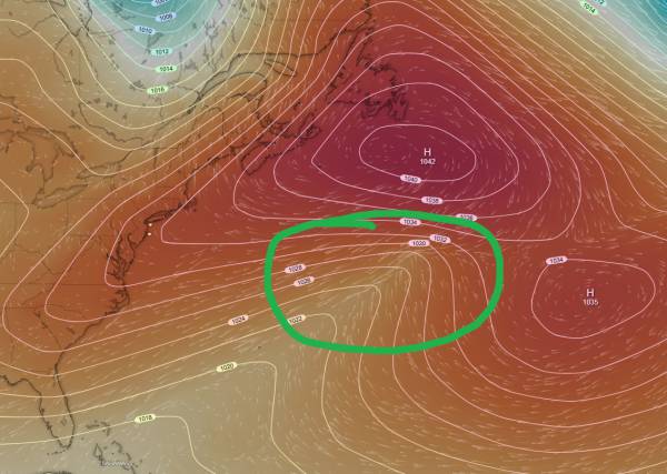
source: windy.com
This is a pretty atypical setup for us. We have two large regions of high pressure over the Atlantic, with a small area of very weak low pressure (circled in green) forming to their southwest. This creates a steep gradient of pressure (wind) that is somewhat well aimed towards our region. It looks like the southeast will see the most size from this setup, but our wind forecast looks pretty good as of 4/7.
Let’s look at that wind:
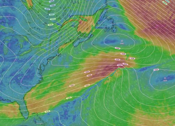
source: windy.com
As you can see, we have a small gale that is primarily aimed WSW with some weaker winds aimed due west (towards us). As the entire group of high/low pressures move east, we’ll see wind a little better directed towards us. That said, the energy from this setup is better aimed to the southeast.
The upside to this setup is that unlike almost every swell we’ve had lately, this one is well offshore. This means that local wind isn’t controlled by the swell producing systems and we don’t require a wind shift for decent conditions. That, combined with the relatively benign patter of coastal weather we’re going to be seeing late week means (at worst) light onshores. It’s hard to call the actual wind this far out, but I’m optimistic.
The Waves
The timing could still change a little bit, but currently I’m seeing around 4ft@10s to start the day on Friday with roughly 6ft@11s expected on the buoys during the peak of the swell. That likely includes some windswell mixing in, but I’d expect fairly punchy surf. Swell should continue into Sunday with swell heights in the 3ft+@10s range. Wind is a bit more of a factor for Sunday with conditions pontentially becoming choppier.
Let’s look at some charts (data source: NOAA NWPS):
Friday 4/10:
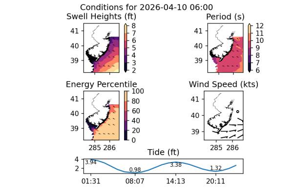
Swell (ideally) starts to show Friday morning. Wind is expected to be light before turning sideshore later in the day. This is a good time period to watch depending on how the wind forecast shifts.
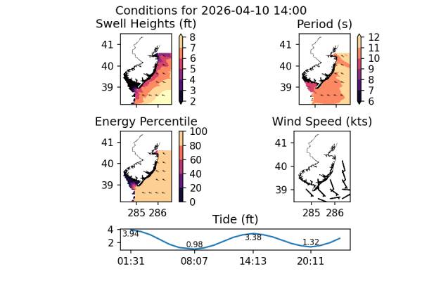
Waves show more size for the afternoon but with potentially worse conditions depending on the wind direction/speed. For those looking to surf the most size from this setup, Friday PM with some south wind protection may be the call.
Saturday 4/11
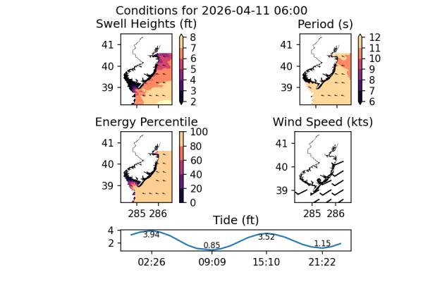
Saturday should be the best day of conditions, all things considered. We have plenty of swell left over and favorable wind until late day. Most likely the best conditions will be early, with offshore winds and the most size.
Sunday 4/12
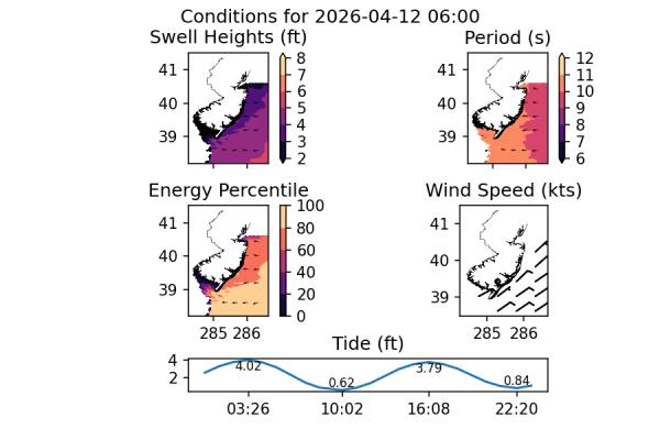
The swell starts to drop on Sunday with swell heights in the 3-4ft range early. I’d expect wind to be light, but it’s unlikely to be offshore. It all depends on a region of high pressure that is moving in and where it is at the time. There will be plenty of swell if the forecast holds, but conditions could be poor.
This may end up being the best day for newer surfers depending on how the wind works out.
Notes
We have a pretty fun looking setup, especially given all the weak prefrontal swells we’ve been seeing this year. It’s nice to see that a little bit of juice should be on the way. While this is a pretty low probability setup when it’s further out, now that we’re only a few days away, I’d say we have a pretty good chance of this becoming reality.
You’ll want to keep a close eye on your local wind forecast as well as the tides. Luckily, the tide swings we’re seeing over the duration of this swell event are pretty minimal compared to what we saw last time we had an actual swell (3/17).
While I don’t want to put complaints out into the universe right now, this is an almost due east swell which won’t play all that nicely with our sand, especially at 10+ second period. Put the time in to find a good sandbar. Closeouts will be an issue at most spots. We really haven’t had a solid east swell it quite some time, so it’s hard to predict how we’ll handle it.
Expect crowds. It won’d be warm, but it’ll be less cold than it has been.