Forecast Note - Mid March Update
Consistent swell (or at least waves) through the middle of the month!
Three Swell Events are Likely in the Next Week
I’m not sure if the end of February - now has made up for Fall and early Winter quite yet, but we’re seeing fairly consistent (albeit soft) swells as we approach Spring. It’s been pretty hard to complain about the power in the waves lately given how many fun days we’ve had.
The next two swell events will be very much in line with what we’ve been seeing lately, steep-south swells in the six to eight second range. While I’m sure we’d all like to be seeing those numbers get a little higher, it’s working with our excuse for sand and the waves should at least stay open for a turn or two.
Setups and Conditions
Let’s look at each setup swell event by swell event, starting with Thursday 3/12.
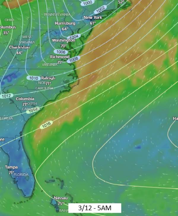
Thursday 3/12

ECMWF MSLP Chart. Source windy.com
ECMWF Surface Wind. Source windy.com
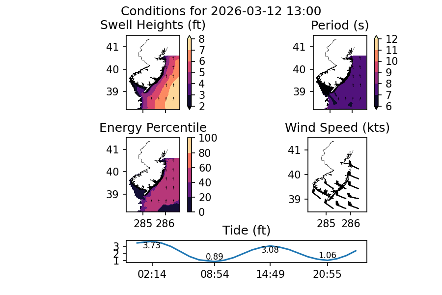
data source: NOAA NWPS
Starting at the first chart (MSLP), you can see a very common setup, a low pressure system bumping up against high pressure over the Atlantic. Given that high pressure and low pressure create wind fields in opposite directions, they create a fetch of same-direction wind when they run into each other that accelerates as they near. The red arrow shows the track of the low pressure system.
The second chart is the wind speed at the surface and as we can see is a fairly decent fetch. Annoyingly, North Carolina blocks any of the swell to it’s south, which would have likely allowed us to see more mid-period mix in. I’ll go out on a limb and say that we should expect some mid-period energy in the 9 or 10 second range to mix in even though I’m not seeing that on the models right now. Thank the inland track of that low pressure system.
Last up, we have our conditions. Models are suggesting that we’ll see buoy heights in the 4-6ft range at 7-8s period. Wind is expected to shift hard offshore behind the passage of this frontal system which is both good and bad. I’d definitely expect some sideshore current to be running. Expect to stay active out there.
All in all, it looks like a pretty fun swell and should show decent conditions at most spots in the area. We could see some leftovers on Friday, but I’d have low expectations for size at this time with waist high waves likely. Get on it early.
Saturday 3/14
We have another low pressure system moving through our region Friday afternoon. This won’t be quite as impressive as the system we see move through on Wednesday/Thursday, but it should still be enough to kick up some decent sized short period surf for Saturday AM.

ECMWF Surface wind. Source windy.com

Data source: NOAA NWPS
While the swell numbers are similar to what we see on Thursday, I’d expect this to fade really quickly and stay in the lower period values with no mid-period swell mixing in. It’s important to note that Thursday’s swell is better directed as well.
Looking at our conditions for Saturday, models are predicting buoy heights in the 5-6ft range at 7-8 seconds. Wind is again expected to shift strong offshore following the passage of the low pressure system.
Swell is expected to fade quickly with the early AM showing the most size and it’s looking marginal by end of day.
Should be fun!
A Stronger Swell?
We could see a stronger swell event on Monday 3/16. Let’s look at the wind chart for Sunday evening:
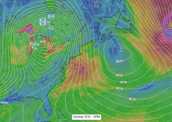
ECMWF Surface wind. Source windy.com
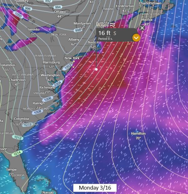
ECMWF waves. Source windy.com
We have a stronger low pressure system interacting with a large region of high pressure over the central and western Atlantic. There is still some uncertainty in the track that the low pressure system will take, but we should see a solid swell event regardless. The GFS model is suggesting a steeper south swell than what is shown above.
Looking at the wave chart, we can see that seas up to 16ft are currently expected. This is consistent across both the ECMWF and GFS right now, though the GFS is predicting a longer fetch with more mid-period swell.
While it’s much too early to start talking about conditions, this is looking like a solid swell and overhead surf is likely. We are pretty much guaranteed an offshore wind switch due to the type of setup we’re looking at as well. It’s a little early for more detail than that.
I would expect Monday to be an experts only day if it comes together, with fun/solid leftovers on Tuesday and some grovel waves on Wednesday. Favorable conditions are expected throughout. The main question is whether or not the wind switch will happen before dark on Monday.
Looking Ahead
I’d expect things to slow down for a little bit after Monday’s swell event. High pressure is expected to move in and remain dominant over the Eastern U.S. for around the following week, preventing and new swell. As for right now, the next possible swell event looks like Monday 3/21. Not a terribly long wait, especially considering how good early-mid next week is looking!