Forecaster's Note for March First
How Things are Looking
Our weather pattern has definitely changed and is fairly consistent with expectations based on long range models. High pressure is dominating over the Atlantic and is strong enough in the western Atlantic where we’re starting to see low pressure systems take a more inland track as the jet stream gets pushed further north.
While this isn’t an ideal setup, there’s still swell on the charts, although nothing particularly exciting or historic. Overall, I’d expect more trade-like-swell for at least the next week or two. This means shorter period swell with more periods of poor wind as we don’t have a front pushing through with the characteristic wind switch. It does look like we’ll luck out with some offshores for each of the next couple of swells, but it’s not a sure thing with systems like this.
In other news, we have a strong positive phase of the NAO right now. This contributes to the high pressure over the Central Atlantic and means we have a statistically higher chance of dry/warm weather coming our way. Typically, this isn’t a good thing for swell, but I’d like to feel warmth again and the charts aren’t all that bad.
Our Next Swell Event
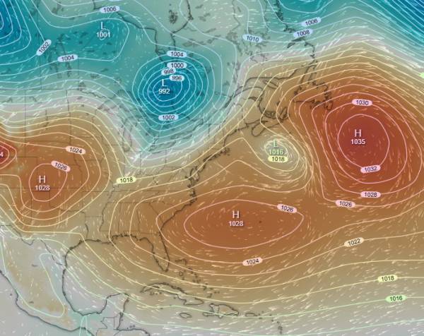
First, let’s look at the mslp chart to just get an ideal of how the Atlantic is looking:
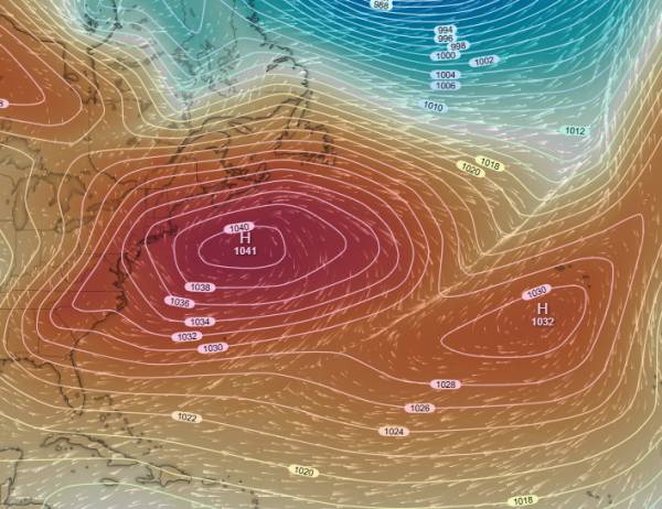
source windy.com
As you can see, we have a massive region of high pressure that is expected to move into our swell window sometime around Tuesday. Let’s look at the wind chart:
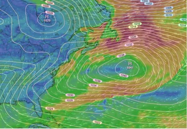
source windy.com
We get a fairly short fetch of decently strong wind from this setup that should net us some 3-5ft short period waves in the six or seven second period range for mid-week. While this isn’t a particularly powerful swell, it means we should continue to see consistent surf for our region.
As an aside, Florida is going to be getting some pretty solid surf from this. It’s a shame the wind isn’t going to switch. Look at that fetch!
Another High Pressure System Follows
Around Friday 3/06 we should see another large high pressure system move through, though an easterly fetch is expected this time:
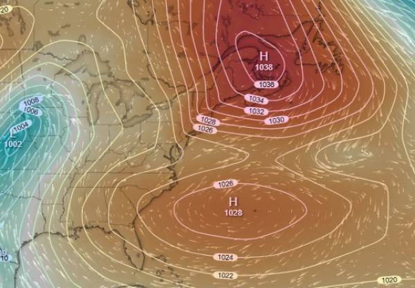
source windy.com
Note that those two high pressure systems create opposing wind fields, so that doesn’t help our swell.
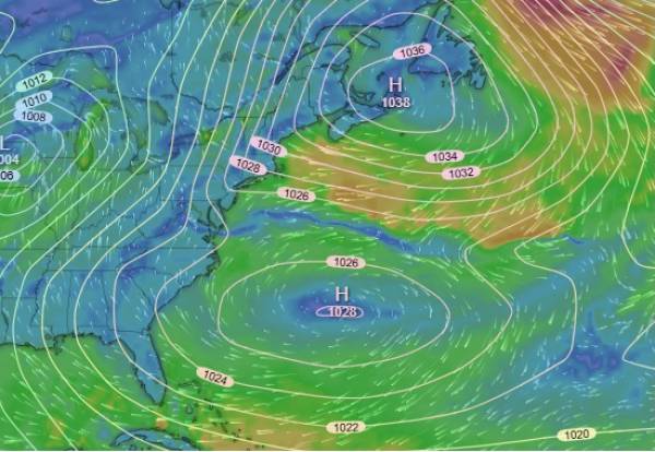
source windy.com
We should end up seeing some combo swell from these two systems. Small changes in the location or strength of these regions of high pressure could affect the swell we see, so I’m not that confident in the swell forecast at this time. However, we should get some waves. Currently, numbers in the 3-5ft range are expected with swell from that easterly fetch to likely be in the ten second range.
Inland Tracks for Low Pressure Systems
source windy.com
If you look up at the pressure chart for that second high pressure system, you can see a region of low pressure over the Great Plains. Looking at the image above, you can see the track that it is taking is northeast (almost NNE). That wall of high pressure over the western Atlantic is going to be a problem for coastal storm tracks until something shifts in the pattern.
Somewhat ironically, this is almost the inverse of the problems we had in early February. Other than Nor’easters, we didn’t have any high pressure to bump into and given the northerly tracks of low pressure, they were too far north to be in our swell window. No high pressure to the south meant we couldn’t get any prefrontal swells. Now, we don’t have any low pressure systems at all.
How Long will this Continue?
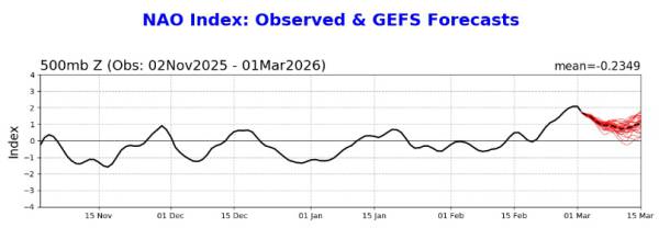
It’s hard to say. The Climate Prediction Center has our current strong phase of the NAO starting to decrease in strength back towards neutral. In so far as that is having an effect, we should be at the peak right about now.
source: NOAA Climate Prediction Center
It’s hard to believe charts as far out as mid-next week, but I’m seeing an area of low pressure that’s expected to track through our region and in our swell window. High pressure is weaker over Bermuda for that time as well.
All in all, I’m still pretty optimistic about our odds through mid-March (at least for consistent and fun surf).