Forecaster's Note for February
Reasons to be Optimistic?
The Current Set Up
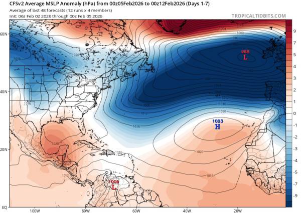
Courtesy of tropicaltidbits.com
This is the surface level pressure anomaly chart for today (2/5) through 2/12. It’s fairly similar to what we’ve had for a couple of weeks. The blue shaded regions represent low pressure anomalies and the red shaded represent high pressure anomalies.
Some Context
As you can see, the north central Atlantic is and has been dominated by low pressure. Let’s take a second to understand what that means in the context of wind and swell generation. Storms move from west to east and their wind fields are stronger in the direction they are moving. This is the reason west coasts all around the globe get stronger swells than east coasts.
For us, other than hurricanes, that means that we need high pressure set up over the western Atlantic to interact with low pressure systems as they pass our region. When low and high pressure systems interact, they create stronger winds because they spin in opposite directions. It’s similar to a pitching machine if you’ve ever played baseball. Since hurricanes move south-north and west-east, they can generate swell on their own without any interactions, but interactions generally cause larger fetches and stronger winds.
There are times when two low pressure systems can chain together and generate swell (typically NE), but those are low probability events for our region.
Looking Forward
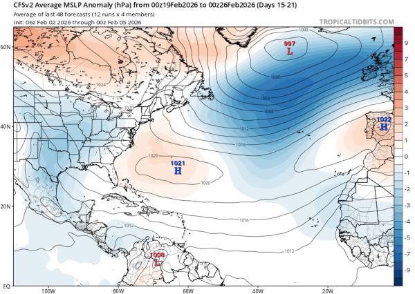
Courtesy of tropicaltidbits.com
This chart shows mid-Feb through the end of February. As you can see by the red shaded area around Bermuda, we have high pressure set up over the western Atlantic (the Bermuda High). This is actually a particularly great chart for us. High pressure anomaly over Canada means storm tracks should be further south and then low pressure anomaly over the great planes helps confirm.
The two weeks following have similar charts.
This is a good setup for southeast swells, which we pretty desperately need after the paucity of them we’ve seen this year. A more southerly storm track increases the probability that we see them relative to the northerly storm tracks we’ve seen in the last quarter of 2025 and early 2026. In real terms, this means less steep south - SSW swells and more southeast and ESE swells.
Conclusions
While things look pretty slow this week, I think there is solid evidence that things should be improving. More southeast swells should be on the way and we could see an active end to winter, which frankly, we deserve after what we’ve put up with this year. I’m expecting a lot more consistent surf than we’ve seen in the past couple of weeks.
There is some evidence of an early spring, which could potentially slow things down after mid-March. It’s too early to make any calls of course, but it’s something to keep in mind. The positive, of course, is that we would experience temperatures fit for living instead of hibernating, which seems like a dream at this point.
Anyway, get through the next week or so, stay warm, and hopefully things change for the better.